Learning Objectives
After reading this chapter, students should be able to:

describe the geography, topography, and climate of South Asia, and its effect on the region's trajectory
explain the nature of the long era called the Mesolithic, and what unifies this period archaeologically
understand the origins of and transition to agriculture in South Asia, and the debates surrounding these processes
characterize the relationship between the fertile floodplains and the resource rich highlands through time
describe the traditions of craft specialization from earliest to historic times
explain the factors in the rise of complex societies in the Indus region
characterize the Harappan urban complex
explain the uniformity and diversity found within Harappan cities and their hinterlands
discuss the history of thought surrounding Indus social organization
describe the origins, use of, and attempts to decipher the Indus script
characterize the collapse of the Indus urban world
trace the history of thought on the collapse of Indus civilization
explain why Shaffer and others describe the Harappan sequence as eras of "regionalization, integration, and localization"
describe the societies that rose in the post-Indus era, and why the concept of a "dark age" has been abandoned
trace the characteristics of the post-Indus cultures through to the Early Historic era
characterize the kingdoms and empires of the Early Historic period
understand the social, political, and religious changes and developments of the Early Historic era
assess the impact of outside contact and conquests on the South Asian subcontinent
LAND AND LANGUAGE
South Asia (modern India, Bangladesh, Nepal, Bhutan, Pakistan, the Maldives, and Sri Lanka) has geographical, linguistic, historical, and archaeological links with parts of Afghanistan and Iran. Its borders are the Bay of Bengal, the Arabian Sea, and the Hindu Kush, Pamir, Karakoram, and Himalayan ranges.
The most obvious features within the region's extremely varied topography and environment are the Indus and the Ganges river basins, but also include deserts, plateaus, northern and tropical regions.
The Foundations: 26,000-6500 BC The peopling of South Asia is not well understood, although this is improving. A chopping tool found in Pakistan dates to 2 million years ago, earlier than the earliest hominid remains, the
Homo species "Narmada Man," (250,000 years ago). Early anatomically modern
Homo sapiens are first seen in Sri Lanka about 34,000 years ago.
The Mesolithic period dates to between 26,000 and 1800 BC. A long era, it is characterized by broad-spectrum subsistence strategies and microlithic blade industries, grouped into four regional archaeological zones:
Western India This region is represented by the key sites of Bagor (5000 BC to AD 200) and Langnaj (3rd millennium BC), located among dunes along rivers. They yielded microlithic tools, a broad spectrum of faunal remains, and later at Bagor, ceramics, copper, and eventually iron objects, and at Langnaj, querns and grain.
The Ganges Plain The second area comprises open-air settlements along the Ganges system, exemplified by the 9th-millennium BC site of Sarai Nahar Rai. Two structures, 12 burials, and 12 hearths yielded fauna from broad-spectrum economy. Other important sites are Mahadaha and Damdama, and at Bagor, atypical postholes and rubble blocks represent windbreaks or sunshades. Large numbers of grinding implements suggest a reliance on plants.
Central India Rockshelters and caves are typical site locales in Central India. An important site is the shelter of Adamgarh, where microlithic tools and indications of a broad-spectrum subsistence pattern are found, along with domesticated dog, cattle, buffalo, sheep or goat, and pig. Similar remains at Ghagharia rockshelter suggest that such sites were animal- and plant-processing centers.
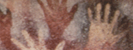
The Bhimbetka shelter complex (6th millennium BC - 1st millennium BC) has hundreds of paintings of humans hunting deer, cattle, buffalo, rhinoceros, monkey, and porcupine, as well as collecting honey and plants, associated with microlithic tools and inhumations with grave goods.
Sri Lanka Sri Lanka was linked to the Indian mainland by a land bridge as late as the 6th millennium BC. Sri Lanka contains the earliest microlithic tools in South Asia (c. 26,000 BC), and the earliest anatomically modern human remains.
Rockshelters provide the best and earliest evidence, such as Batadomba Lena, with middens, bone points, beads, microliths, and burials dating to 26,500 BC. Plant and animal remains are found at Kitugala cave, dating from 25,000 to 1400 BC.
In the northern semi-arid lowlands, an occupation dating to 1800 BC contained geometric microliths and marine food resources. Excavations at Anuradhapura in the island's dry zone comprise microlithic tools dating to 3850 BC.
Assemblages of the Ganges plains and the Vindhyan escarpment differ. The latter had more and bigger tools, with larger, less worked cores. Sharma suggested these were winter hunting camps used during seasonal animal migrations from plains to hills. In summer, an opposite migration down to lakes in the plains occurred. This model is also applicable to western India, supported by the occurrence of lithic and shell material at sites between 80-100 km (50-60 miles) from their sources.
This pattern may have encouraged territoriality, suggested by human remains (ancestors) within middens; conflict may be indicated by a microlithic blade embedded in the ribs of one burial at Sarai Nahar Rai. Extended burials in the Ganges plain and flexed ones in Gujarat may represent regionalization, and increasing grave goods indicate increased differentiation. Diet included as much as 60 percent plant content. Some communities went on to domestication while others continued to hunt and gather until recent times.
EARLY NEOLITHIC VILLAGES: THE FIRST FOOD PRODUCERS
Today, researchers identify four geographically and culturally distinct Neolithic clusters. Two clusters, in west and peninsular India, indicate strong regional contributions toward domestication; the other two, in Kashmir-Swat and along the Ganges, may originate elsewhere.
Neolithic sites are characterized by ground-stone tools, domesticated plant and animal species, the introduction of ceramics, and the establishment of settlements, although these attributes vary.
Western Pakistan South Asia's earliest known Neolithic communities were located in Baluchistan, where in the 7th millennium BC, small agricultural villages were established near passes leading to the Indus plain. The earliest is Mehrgarh, a farming and pastoral community dated to c. 6500 BC. Later sites include Kili Ghul Mohammad and Rana Ghundai (5th millennium BC) which contain mud-brick structures, chert blades, bone points, and handmade ceramics, and domesticated sheep or goat, cattle, wheat, and barley. They were linked through trade networks that brought turquoise, marine shell, and steatite beads from communities to the north, south, and west.
Before the discovery of Mehrgarh, most scholars had assumed that Neolithic communities spread slowly from Southwest Asia, but colonists would have had to begin spreading at 8600 BC to arrive at Mehrgarh, too early to be likely.
Additionally, farming in this region involves the domestication of native cattle rather than sheep and goat, and the early layers are aceramic, at odds with the arrival of a "package" from Southwest Asia. This region's Neolithic probably developed locally.
Kashmir and the Swat Valley The second cluster emerged in the 4th millennium BC. Over 40 sites, such as Burzahom ( from 3000 BC onwards) saw coarse ceramics appear between 2850 and 2250 BC. Bell-shaped pits containing ceramics and faunal remains may be semi-subterranean dwellings. The pits were no longer constructed once mud-brick and timber structures appeared. The site of Gufkral indicates subsistence on game, sheep, goat, wheat, barley, and lentils.
The evidence from Pakistan's Swat Valley is similar, although somewhat later (1700 and 1400 BC). Kalako-deray and Loebanr III contain similar bell-shaped pits, some stone paved, others with burning, containing terracottas in human and animal forms, ceramic vessels, polished stone objects, stone sickles, hammer stones, grinding stones, bone objects, and jade beads. Paralleling Kashmir, pits were abandoned when mud-brick structures were erected.
Language, artifacts, and subterranean dwellings suggest contact with Neolithic Central and East Asia. Others believe the pits merely provided winter grain storage for transhumant rather than sedentary communities. The evidence is still unclear.
The Ganges Basin The third Neolithic complex contains sites close to the seasonal settlements of the preceding period.
Chopani Mando contains huts, cord-impressed ceramics, ground-stone tools, and querns; wild rice and undomesticated cattle and sheep or goat suggest a transitional settlement. Sharma suggests that nearby Mahagara represents the next step: 18 huts centered on a stockade or pen may have belonged to eight households with perhaps 250 individuals. Specialization is suggested by the uneven distribution of querns and stone tools.
Controversy surrounds the identification, dating, and provenance of domesticated rice at the key Neolithic sites of Mahagara, Koldihawa, and Chirand. Rice domestication was probably not introduced until the middle of the 2nd millennium BC, but many South Asian archaeologists believe that rice domestication was indigenous.
Peninsular India The final Neolithic complex is dated to between the 4th and 2nd millennia BC, and comprises two site categories: over 50 ash mounds and larger open area settlements. Ash mounds were formed by the burning of successive phases of stockades or pens. At Utnur, burnt stockades contain cattle hoof-prints.
Polished stone axes, blades, and coarse ceramics link these with larger villages of circular boulder-and-stake structures. Paleobotanical sampling at Tekkalakota, Sangankallu, and Hallur indicates indigenous domesticated plants, including pulses, millets, and tubers or rhizomes.
AN ERA OF REGIONALIZATION: EARLY HARAPPAN PROTO-URBAN FORMS
By the 4th millennium BC, inhabitants of the Indo-Iranian plateau had colonized the Indus floodplain, and by the 3rd millennium BC had created fortified, planned settlements. By c. 2800 BC, the Early Harappan period, or Kot Diji phase, emerged with over 300 identified sites, termed an "era of regionalization" by Shaffer.
Mehrgarh emerged as a regional center of ceramic production, as did others in Baluchistan. These communities are divided into Kachi, Kili Gul Muhammad, Kechi Beg, and Faiz Muhammad phases (after individual type sites), dating to c. 5000-2600 BC. Painted wheel-thrown ceramics were produced; also copper, shell, and stone artifacts. Contact with large, permanent settlements to the west and north is indicated, including Shahr-i Sokhta and Mundigak.
The earliest Indus plain habitations are exemplified by the 4th millennium BC sites of Balakot and Amri containing mud-brick structures and decorated wheel-thrown ceramics. Barley and domesticated and wild animals were consumed.
Further north, the Hakra ceramic complex is found. Small, temporary settlements and a few larger, permanent settlements both contain distinct wheel-thrown ceramics, microliths, terracotta figurines, and bone and metal artifacts. Important Indus cities, such as Harappa, were established during this phase.
Kot Diji and Early Pointers Toward the Indus Civilization The Kot Diji ceramic style (after Kot Diji, Pakistan), the first clear Indus Valley cultural convergence, succeeded the Hakra complex. Dated to c. 3200-2600 BC, the wheel-thrown, globular red-ware jars have geometric, bulls' head, fish, and pipal leaf decorations. The makers lived in planned settlements of mud-brick buildings. Fortifications have been identified at Kot Diji. Other informative data come from the sites of Rehman Dheri, Kalibangan, and Harappa: planned, rectangular settlements with mud-brick walls enclose large areas with rigid grid-iron street plans. In the Cholistan Desert, two larger settlements dominated a hinterland of 38 smaller sites, suggesting increasing centralization.
Kot Diji ceramics also are found in the Kashmir Valley, Sindh, Baluchistan, and southern Afghanistan, indicating trade routes. Many Early Harappan sites exhibit multiple functions. Non-scriptural graffiti indicate a need for record-keeping.
AN ERA OF INTEGRATION: THE INDUS CIVILIZATION
The Indus, or Harappan, (after Harappa, Pakistan) is a Bronze Age civilization termed an "era of integration" by Shaffer, The "mature" phase is dated to 2600-1900 BC, and encompassed 500,000 sq. km (193,000 sq. miles). The Indus civilization is characterized by a four-tier settlement hierarchy, cities, urban planning, writing, artifact standardization, long-distance trade, craft and settlement specialization, and monumental public works.
A Hierarchy of Settlement Forms At its peak, five urban sites existed: Mohenjo-daro, Harappa, Dholavira (larger than 100 ha (247 acres) each), and Rakhigarhi and Ganweriwala (c. 80 ha (198 acres)). Possehl has suggested that Mohenjo-daro, Harappa, and Dholavira were primary centers within the lower Indus, western Punjab, and western India respectively, while Rakhigarhi and Ganweriwala are situated close to the old course of the Ghaggar-Hakra River.
At Harappa, recent excavations by Kenoyer and Meadow indicate four walled mounds around a central depression, which may have held water. Each mound was entered through narrow gates and contained a similar array of craft manufacture and finished artifacts. These mounds are linked by sealings from the same seals. Dholavira is quite different: a city wall encloses a complex of further walled compounds. Large structures lie on an acropolis; the lower town houses craft activities and is subdivided by cardinal streets. Little is yet known about Rakhigarhi and Ganweriwala.
The next tier includes 32 sites that are less than 20 ha (49 acres). Many were walled and internally planned. A third tier is comprised of small walled sites of 2-4 ha (5-10 acres). Finally, over 15,000 sites are under 1 ha (2.5 acres); agricultural villages or economically specialized settlements. Communities of hunter-gatherers and pastoralists may have been economically drawn into the Indus sphere as well.
Erroneous portrayals of the Indus civilization as inherently peaceful originate with John Marshall, excavator of Mohenjo-daro and Harappa in the 1920s, suggested by flaws in weapons and defensive architecture, and absence of elite martial grave goods and representations of war or warriors. However, as any type of elite differentiation is lacking within Indus settlements, martial displays should not be expected. Representations of war may not have survived. The massive walls in Early and Mature Harappan sites are conspicuous defenses, although they may also have had symbolic, ritual, or anti-flood functions. Indus civilization likely experienced warfare, but did not celebrate or ritualize it as did others.
Subsistence and Trade Settlements lay on the floodplains of the Indus and Ghaggar-Hakra rivers, where fertile land was annually refreshed by inundation. Recent research has identified wheat and barley, pulses, millets, fibers/oilseed, melons, cucumbers, squashes, and rice. Cattle, water buffalo, goat, and sheep provided animal products.
Floodplains lack raw materials; urban economies provided surplus for exchange to obtain them. Kenoyer proposed a series of trade or resource routes linking the urbanized centers with sources of lapis lazuli, carnelian, steatite, shell, chert, tin, copper, and gold. These materials, once processed, were redistributed within the Indus region and the surplus was traded across the Persian Gulf as far as Elam and Mesopotamia.
The Western Borderlands Baluchistan, though never absorbed into Harappan civilization, was internally integrated, suggested by the broad distribution of Kulli-phase ceramics (2500-2000 BC). Major public complexes were built at Las Bela and Nindowari, perhaps to compete with or mimic their complex neighbors.
AN ERA OF LOCALIZATION: THE ECLIPSE OF THE INDUS CIVILIZATION
The causal factors behind the Indus civilization's collapse c. 1900 BC are still debated. Physical manifestations include the loss of planned urban forms, monumental public buildings, and a written script. New cultural traits appeared, and local, pre-urban traditions re-emerged.
The Core Cities The cities of Harappa and Ganweriwala were lost, together with their distinctive urban traits, replaced with fewer, smaller, and less specialized communities. Termed Cemetery H or the Late Harappan, excavations at Harappa indicate that extended burials were replaced by disarticulated remains placed within black on red burial vessels.
In Cholistan and Sindh the number of sites dropped; Mohenjo-daro and Chanhu-daro were largely abandoned. This post-urban Jhukar phase yields stamp seals, copper pins, and shaft-hole axes with western or central Asian affinities. This is paralleled in Gujarat, although smaller settlements actually increased. A number of earlier styles and traditions re-emerged.
Peripheral Areas In Baluchistan, settlements were abandoned or burned around 1900 BC. Mundigak (Afghanistan) presents a contrast: on the remains of a palace, a further monumental structure was erected, while central and western Asian items of gold, stone, and copper increased in cemeteries. At Pirak (1700-1600 to 700 BC) there is clear continuity in settlement, craft specialization, and trade networks.
By 1700-1600 BC the Gandharan Grave culture was spreading. At Balambat, Timargarha, Aligrama, Bir-kot-ghundai, Kalako-deray, and Loebanr I, homogeneous burials, pottery, and other artifacts are found. This culture may extend into Afghanistan, Peshawar, and Taxila and perhaps the southern Himalayas.
Archaeologists have identified a few settlements with links to the Harappan period in the Ganges-Yamuna doab. During the post-urban period, the Ocher Colored ceramic complex appeared, dated to c. 1700-1200 BC. It is linked to the Harappan tradition, and is found in the lower strata of sites that later emerged as the centers of city-states in the Early Historic period.
To the south and west, complex communities of the western Deccan flourished c. 2100-700 BC. A chiefdom with a three-tier settlement hierarchy may have been centered on Diamabad, with sub-regional centers at Prakash and Inamgaon, and numerous smaller agricultural sites. The associated port site of Malvan contains shell, gold, ivory, carnelian, and copper, suggesting trade.
THE RE-EMERGENCE OF REGIONALIZED COMPLEXITY
The period between the Harappan collapse and the emergence of the Early Historic or Gangetic civilization was once referred to as a "dark age," but recent scholarship indicates continuity. This period (1200-500 BC), saw the emergence of fortified settlements, planned urban forms, states, the use of seals, script, and mass production. Iron tools first appeared. Several religious teachers, such as the Buddha, date to this period, which ended when the Achaemenid Persian Empire conquered the western subcontinent in the late 6th century BC.
Developments in the Northwest and East The western subcontinent saw conversion into Achaemenid satrapies, each with an administrative center, such as at Kandahar, which had a high citadel and a wall. The Achaemenid horizon sits on an already fortified earlier settlement of the 1st millennium BC, on a route from the Indus to western and central Asia. Parallel developments occurred at Taxila and Charsadda, To the east, the number of small settlements in the Ganges-Yamuna doab region expanded and the Ocher Colored tradition was replaced by Painted Gray ware, dated to between the early 1st millennium BC and the 6th or 7th century BC, and associated with iron use. It was superseded in the 6th century BC when Northern Black Polished ware, a direct descendant, spread throughout the subcontinent. Hastinapura provides a good example of Painted Grey ware settlement expansion. Expansion is also seen in the Ganges basin where centers emerged in the 6th century BC, constructing large earthworks and using coinage from the 5th century BC.
By 500 BC, emergent
janapadas, or territories, had coalesced into 16
mahajanapadas, or "great territories," each with a capital and ruler, ministers and courts, supported by taxes and campaigns, vying for supremacy. A good example is the kingdom of Vatsa.
Southern India and Sri Lanka Cultures of the Deccan Plateau pursued a massive investment in stone funerary complexes. Recent intensive survey has identified associated settlements. Brahmagiri, Maski, and Hallur, were continuously occupied from the 3rd millennium BC into the Early Historic period.
In Sri Lanka, recent data comes from the city of Anuradhapura, the island's capital until the 11th century AD. Excavations indicate that it was established as a simple community around 900 BC, expanded to a manufacturing center by 450 BC. Researchers have found early Brahmi inscriptions on trade and exchange, signalling that writing re-appeared by 400 BC.
RE-INTEGRATION: THE EARLY HISTORIC EMPIRES
The regionalized developments in Afghanistan, Gandhara, the Ganges basin, central India, and Sri Lanka were interrupted in the northwest by annexation into the Achaemenid empire in 520 BC, but the actual impact is less clear.
Archaeological evidence for Hellenistic invasion and colonization of the Indus region by Alexander the Great in 326/325 BC is extremely poor. The closest example of a Greek presence is the Hellenistic city site of Ai Khanoun in northern Afghanistan.
It is now apparent that competition, emulation, amalgamation, and religious patronage resulted in the convergence of the 16
mahajanapadas of central India into a single integrated unit, the Mauryan empire, by 350 BC.
The Mauryan Empire The Mauryan dynasty ruled for more than 150 years. The third emperor, Asoka (reigned 272-235 BC) is known for edicts written on boulders, stone pillars, or slabs. These, combined with early texts such as the Arthasastra, enhance understanding of imperial politics and structure.
Asoka attempted to create a pluralistic unity from the diverse populations of South Asia, and promote major philosophical elements of the Early Historic world: forsake violence and greed, show reverence for animals, establish works of public benefit, rectify administrative evils. Asoka's patronage resulted in the Buddhist conversion of Sri Lanka.
Archaeological evidence includes excavations at the 1350-ha (3336-acre) city of Pataliputra, which controlled a six-tier settlement hierarchy. Mahasthan, a provincial capital, represents an Early Historic fortified city. The Mauryan pacification of South Asia allowed freer movement and networks for trade, leading to standardization of artifacts and craft specialization.
By 350 BC, Anuradhapura covered 66 ha (163 acres) enclosed by a ditch and rampart, paralleling re-urbanization elsewhere.
Post-Mauryan Dynasties Mauryan influence dissipated in the 2nd century BC, giving way to small states. The Gangetic heartland was ruled by the Sunga dynasty. The northwestern region was absorbed into the expanding Greek kingdoms in Bactria that controlled the Hindu Kush. In the 1st century BC, a people known as the Sakas, of Central Asian origin, established a polity in the region. Although the northwest was never formally absorbed into the expanding Parthian empire, it was incorporated into the Indo-Parthian kingdom of Gondophares (reigned AD 20-40).
The Kushan, Satavahana, and Later Dynasties The region was reunified in the first half of the 1st millennium AD through the rise of the Kushans in the north and the Satavahanas in the south. A large Kushan empire established cities and dynastic cult centers, creating a renaissance of Buddhism in South Asia, which spread into Central and Eastern Asia along the Silk Route, evidenced at Begram (Afghanistan) where ivories, Chinese lacquerwork, and Roman metalwork and glass were found.
To the south, the Satavahana dynasty emerged in peninsular India, expanding to cover the Deccan Plateau, until its decline in the 3rd century AD. A Hindu dynasty, they were also patrons of Buddhist art and architecture. Satavahana rulers established capitals and were engaged in maritime Silk Route trade, supported by finds of Roman bronzes, coins, ceramics, and glass.
To the south, the Sri Lankan state continued to thrive, with Anuradhapura as the capital of the entire island in the 4th century BC.
The establishment of the Gupta empire of northern India by Chandragupta I (reigned AD 320-335) represented the end of the fragmented Early Historic period, and ushered in a new imperial system.
Box Features
Key controversy: Foreign Contact and State Formation 1: The Indus Cities
Key controversy: The Decipherment of the Indus Script
Key controversy: The End of the Indus Cities
Key controversy: Foreign contact and State Formation 2: The Early Historic Cities
Key controversy: Roman Contact and the Origins of Indian Ocean Trade
Key site: Mehrgarh. An Early Farming Community
Key sites: Mohenjo-daro and Harappa
Key site: Taxila
Key Controversy: The Antiquity of Caste
Key Controversy: Early Historic Hierarchy and Heterarchies
Key words and terms Chapter 14
Geography
South Asia: India, Bangladesh, Nepal, Bhutan, Pakistan, the Maldives, Sri Lanka
Indus river basin
Ganges river basin
Thar Desert
Bay of Bengal, Arabian Sea,
Hindu Kush, Pamir, Karakoram, Aravalli, Himalayan ranges
Vindhyan escarpment
Deccan Plateau
Eastern and Western Ghats
Kothari River
Mantai lowlands
Malwattu River
Indo-Iranian Plateau
Baluchistan
Bolan River
Belan River
Palk Straits
Rehman Dheri
Ghaggar-Hakra River
Balakot
Surkotada
Makkran coast
Bahawalpur
Sarai Khola
Cholistan Desert
Indus civilization: Punjab, Sindh, Gujarat
Indus civilization periphery: Afghanistan, Baluchistan, North West Frontier Province, Gangetic plains, western Deccan
Rann of Kutch
Rohri Hills
Badakshan
Chitral
Dir
Swat
Vale of Peshawar
Taxila
Hathial ridge
Himalayas of Uttar Pradesh
Ganges-Yamuna doab
Begram
Kandahar
Gandhara
Charsadda (Pushkalavati)
Languages
Indo-European
Dravidian
14 official languages
1652 native tongues
Brahmi
Kharoshthi script
Hominin species
Narmada Man
Phases, periods, cultures, kingdoms, empires
Mesolithic (26,000 and 1800 BC)
Aceramic Neolithic
Kulli-phase
Kot Diji/Early Harappan Phase (3200-2600 BC)
Era of Regionalization
Chalcolithic
Nal, Zhob, and Quetta
Kachi, Kili Gul Muhammad, Kechi Beg, Faiz Muhammad phases
Hakra phase
Mature Harappan Phase (2600-1900 BC)
Era of Integration
Indus civilization
Indus civilization collapse
Late Harappan, post-urban (1900-1200 BC)
Jhukar Phase
Era of Localization
Gandharan Grave culture
Ocher Colored pottery complex (1700-1200 BC)
"Dark Age" (1200-500 BC)
Early Historic Civilizations (500 BC-AD 480)
Era of re-emergence of regionalized complexity
Achaemenid Persian empire in India
Kingdom of Vatsa
Hellenistic colonization
Mauryan empire
Sunga dynasty
Greek kingdoms of Bactria
The Sakas
Indo-Parthian kingdom
The Kushan, or Yuezhi kingdom
Sasanian empire
Satavahana dynasty
Gupta empire
Historic people
Buddha
Darius I
Alexander the Great
Asoka
Pushyamitra Sunga
Strato III
Gondophares
Emperor Kanishka
Ardashir I
Satakarni I
Chandragupta I
Sites
Bagor
Langnaj
Sarai Nahar Rai
Mahadaha
Damdama
Adamgarh
Ghagharia
Bhimbetka
Batadomba Lena
Kitugala
Anuradhapura
Mehrgarh
Kili Ghul Mohammad
Rana Ghundai,
Burzahom (Kashmir)
Gufkra
Kalako-deray
Loebanr III
Chopani Mando
Mahagara
Koldihawa
Chirand.
Kudatini
Tekkalakota
Sangankallu
Hallur
Shahr-i Sokhta
Mundigak
Balakot
Amri
Ghaligai Cave
Kot Diji
Rehman Dheri
Kalibangan
Harappa
Mohenjo-daro
Chanhu-daro
Dholavira
Rakhigarhi
Ganweriwala.
Lothal
Surkotada
Kuntasi
Nageshwar
Shahr-i Sokhta
Las Bela
Edith Shahr
Nindowari
Pirak
Balambat
Timargarha
Aligrama
Bir-kot-ghundai
Kalako-deray
Loebanr I
Sarai Khola
Hastinapura
Atranjikhera
Diamabad
Prakash
Inamgaon
Malvan
Bala Hisar
Timargarha
Hastinapura
Kausambi
Kara
Brahmagiri
Maski
Watga
Anuradhapura
Birkot
Ai Khanoun (Aï Khanum)
Pataliputra
Ujjain
Sisupalgarh
Mahasthan
Sanchi
Barhut
Sirkap
Shaikhan Dheri
Sirsukh
Dalverzin-tepe
Pratisthana
Sannati
Dhayakataka
Satanikota
Ter
Bhokardan
Artifacts, features, structures
rock drawings and paintings
bell-shaped pits
polished stone axes
stone querns
hand-made ceramics
cattle stockades or pens
ash mounds
Kot Diji ceramic style
Harappa cemetery H
Quetta hoard
Sibri cemetery
Gandharan burnished red ware
Ocher colored pottery
Northern black polished ware.
Painted gray ware
Fire temple
People
Deraniyagala family
G.R. Sharma
Mortimer Wheeler
Asko Parpola
Rafique Mughal
B.B. Lal
George Dales
Mark Kenoyer
Richard Meadow
John Marshall
Concepts
transhumance
resource territoriality
regional diversity
individual differentiation.
trade networks
indigenous origin of agriculture vs. Southwest Asian imports
indigenous vs. imported rice cultivation
early village communities
colonization of the Indus floodplain
fortified, planned settlements
cardinal orientation of site structures
bull motif
craft specialization
economically specialized settlements
Indus civilization traits: cities, artifact standardization, four-tier settlement hierarchy, writing, long-distance trade, urban planning, craft and settlement specialization, and monumental public works
"peaceful" Indus civilization
absence of elite differentiation
resource routes linking urbanized centers and hinterlands
long-distance trade with Elam and Mesopotamia
Indus collapse: loss of planned urban forms, monumental public buildings, writing
new links to Central Asia
satrapies
Janapadas, mahajanapadas,
re-appearance of writing by 400 BC
Hellenistic colonization
Asokan stone pillars
Arthasastra
Technology, inventions
microlithic blade industries
composite tools
broad-spectrum subsistence strategies
Chalcolithic ceramic production centers
wheel-thrown ceramics
advanced technologies for working lapis lazuli, carnelian, steatite, shell, chert, tin, copper, and gold into finished materials
megalithic burial sites